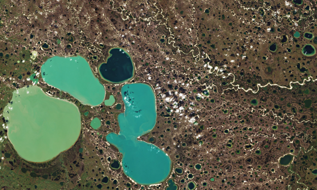
Boreal and Arctic wetlands and lakes are among the world’s largest natural sources of methane (CH₄), a greenhouse gas with a warming potential many times greater than CO₂ over short timescales. Rapid environmental change, including permafrost thaw, changing hydrological regimes, and shifts in surface water extent, is expected to alter methane emissions across northern ecosystems. Despite their significance, methane fluxes from these systems remain difficult to quantify with confidence, largely because the monitoring infrastructure, satellite data products, and process models available today were not built with the scale, seasonality, and remoteness of Arctic wetlands and lakes in mind. Wetlands and inland freshwater systems, taken together, supply something close to half of all methane reaching the atmosphere, yet remain the single largest contributor to the unresolved gap between top-down and bottom-up global methane accounting (Saunois et al., 2020). Closing that gap matters for the Arctic in particular: understanding how much methane these far-northern ecosystems release and when and how that will shift in the decades ahead, is central to gauging the strength of the feedback loop between a warming Arctic and a warming planet.
The two projects MISO and EOWetMet are tackling this challenge from complementary angles: one from the ground-up, through autonomous in-situ sensing (MISO), the other from above, through high-resolution Earth observation and in situ measurements (EOWetMet). Together, they can illustrate how a combined in-situ/satellite approach can begin to close some of the persistent knowledge gaps in Arctic methane science.
MISO develops an autonomous observation system for monitoring carbon dioxide (CO₂) and methane emissions in remote and hard-to-access environments such as Arctic regions and wetlands. Rather than relying on a single sensor type, MISO combines three complementary observing platforms: a static tower-based ambient gas monitor (providing continuous background CH₄ and CO₂ concentration data), a static gas flux chamber (to isolate and quantify point-source emissions), and a UAV-based observatory (extending spatial coverage across remote areas difficult to reach by ground infrastructure), all integrated through a cloud platform. Designed for autonomous operation with minimal on-site intervention, the system incorporates enhanced NDIR (non-dispersive infrared) gas-sensing technologies, intelligent fault detection, machine-learning-based calibration, and multiple communication technologies to enable reliable greenhouse gas observations in challenging environments.
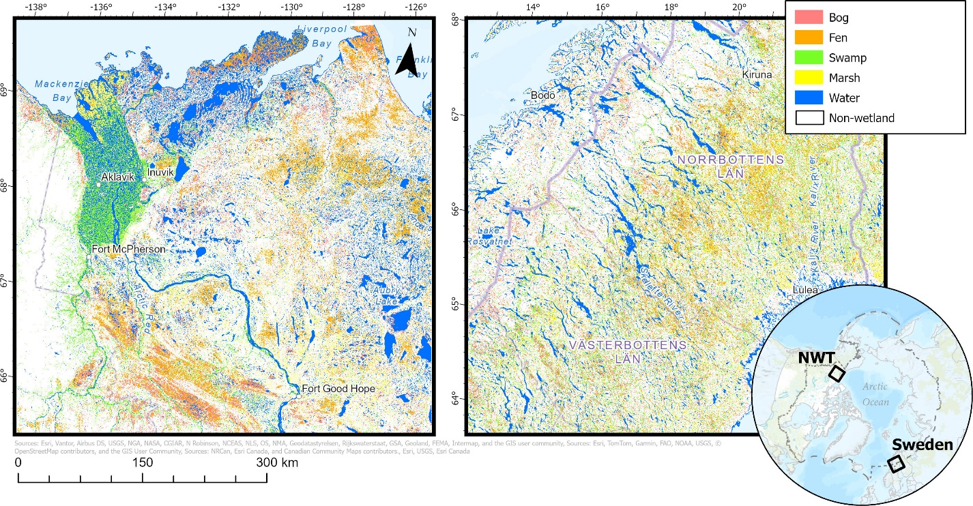
Complementing this observational capability, the EOWetMetproject has advanced Arctic-boreal wetland and lake monitoring through the application of Earth Observation satellite data (mainly Sentinel-2, Sentinel-1 and ALOS-2) and Artificial Intelligence by reducing the uncertainty in methane budgeting due to data resolution and double-counting. Improved wetland classification products have been created through the integration of temporal inundation dynamics as a feature in a machine learning classification framework. New high-resolution seasonal wetland maps have been generated separating wetlands and lakes by capturing smaller and seasonal features that are sometimes missed in existing wetland datasets: https://doi.org/10.1016/j.jag.2026.105315.
The wetland maps have been used to constrain an Arctic Random Forest model trained on Eddy Covariance methane-flux measurements to predict methane flux per unit area. The results of this work will be published soon.
Based on EOWetMet project results additional future developments to be performed within the alliance may include expanding the regional high-resolution products to additional Arctic study areas, incorporating newly available observations and wetland datasets, and updating the Community Assessment Database through future product releases. These efforts will further improve the utility of the database and support ongoing development of EO-based methane monitoring capabilities across northern and Arctic environments.
Where can the combined approach and alliance help?
Even with these advances, the literature on wetland and lake methane emissions points to a set of persistent, well-documented gaps that neither satellite data nor in-situ networks have fully resolved on their own:
- Incomplete and imprecise spatial data on wetland and lake extent: existing large-scale products such as BAWLD-CH4 and the Canadian Wetland Inventory Map tend to systematically underrepresent small lakes and marsh wetlands, partly because of their limited areal footprint and partly because short-term weather variability affects their detectability. Emission rates measured on small waterbodies are frequently upscaled onto spatial datasets better suited to medium and large waterbodies, and poorly resolved waterbody margins — often hotspots for methane flux — compound the error.
- Lack of precision: most global datasets offer only coarse spatial resolution and capture little more than the annual maximum wetland area. This misses the seasonal water-level variation that is often the primary driver of methane emission changes, and it struggles with the inherently blurry terrestrial–aquatic boundaries that define wetlands.
- Poor seasonal and cold-season coverage: most field and spatial datasets describe methane emissions as a snapshot taken during warmer seasons. Cold-season dynamics are particularly poorly represented in current process models, seasonal methane variability from thermokarst lakes during ice-melt periods remains poorly understood, and even the role of groundwater discharge in seasonal Arctic lake emissions is not well constrained.
While concrete collaboration is developing as the projects evolve, the proposed ambition is to develop and share common monitoring test sites, as well as propose integrated test site & data collection protocols. Together, MISO and EOWetMet could help bridge the gap between direct methane observations and large-scale environmental monitoring. MISO provides autonomous, continuous measurements of methane concentrations and fluxes in remote Arctic and wetland environments, while EOWetMet by provides detailed information on the extent, condition, and seasonal dynamics of methane-emitting wetlands and lakes. Combining these complementary observation approaches can support improved methane emission modelling, validation of satellite-derived products, and a better understanding of how Arctic ecosystems respond to climate change.